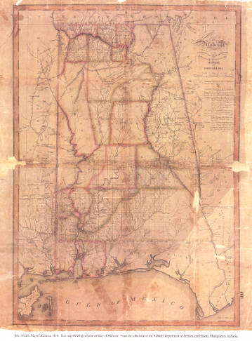
|
 Die neüwe Inselen, so zu unsern zeiten durch die künig von Hispania im grossen Oceano gefunden sindt, 1545. Gift of Rucker Agee.
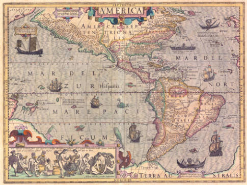
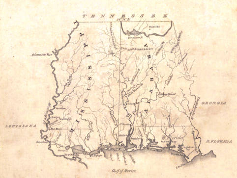
This map of the Americas appears in cartographer Sebastian Munster's Cartographia and"sealed the fate of 'America' as the name for the New World"(Burden, 1996, p. 15). Though the North American land mass is not depicted as accurately as the South (Burden, 1996), the peninsular outline of Florida is clearly visible, with the entire Southeastern region appearing as Terra florida. Other significant features are the inclusion of the Pacific Ocean (Mare pacificum)"for the first time on a printed map. . . Marco Polo's influence can be seen with Zipangri (Japan) appearing three years before the earliest known contact with Europeans”(Burden, 1996, p. 15). Also of note are the Spanish and Portuguese flags as reminders of their dominant status at this point in the New World's development, as well as the representation of Portuguese explorer Ferdinand Magellan's ship Victoria, the only one of five vessels to survive (Burden, 1996).
Click here to view a full size image
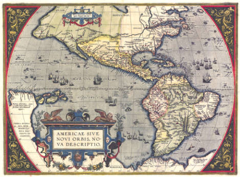 Americae sive novi orbis nova descriptio, c. 1571. Gift of Rucker Agee.
Abraham Ortelius was a Flemish cartographer who is widely credited with creating the first atlas. His work the Theatrum Orbis Terrarum was published in 1570 and enjoyed great success over the next 42 years (Burden, 1996). This is the "first map of the Americas to appear in a modern atlas" (Schwartz and Ehrenberg, 1980, p. 69). The continents of North and South America are instantly recognizable, despite the inaccurate depiction of the South American coastline. The large and "strategically placed cartouche hides a complete lack of knowledge of the southern waters of the Pacific" (Burden, 1996, p. 51).
Click here to view a full size image
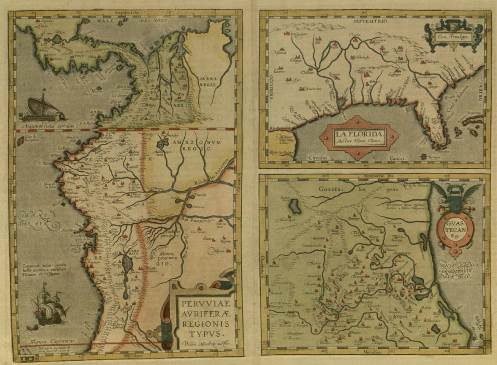 La Florida, c. 1591. Gift of Rucker Agee.
This map originally appeared in the 1584 edition of Abraham Ortelius's atlas Theatrum Orbis Terrarum and in all subsequent editions. Our map appears to be from the 1591 edition. It is the first published map of the area that would become the southeastern United States and "is one of the very few maps printed in the sixteenth century that was based upon original Spanish sources. They were very protective of their knowledge of the Americas, a considerable source of their wealth. . . . it draws heavily upon the findings of Hernando de Soto's expedition through the region in 1539-42" (Burden, 1996, p. 71). Spanish settlements such as Cape Canaveral are indicated as well as Native American tribes and villages. A village that would later go by the name Tuscaloosa is located in the area that is present-day Alabama.
Click here to view a full size image
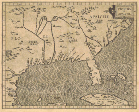 Florida et Apalche, 1597. Gift of Joseph H. Woodward, II.
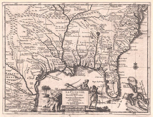
Derived from the Chaves map, this map showing Florida, is one of only three "printed maps of the present day southern United States published in the sixteenth century" (Burden, 1996, p. 129).
Click here to view a full size image
 America, c. 1606. Gift of Rucker Agee.
Jodocus Hondius and his descendants were prolific engravers, publishers, and mapmakers. Hondius was born in Belgium but eventually settled and worked in Amsterdam. This striking map of North and South America appeared in the atlas he produced based, in part, on the work of Gerard Mercator, creator of the Mercator projection. It includes elements such as the skillfully drawn sailing ships and sea monsters that were common features of early maps. The depictions of native people fishing and cooking were taken directly from engravings that had previously appeared in Theodore de Bry's Grand Voyages (Burden, 1996). Interestingly, off the coast of Ireland is a small island called Brasil. This island, while completely fictional, nonetheless appeared on globes and maps for over 500 years (Boston Public Library Norman B. Leventhal Map Center, 2016).
Click here to view a full size image
 Insulæ Americanæ in oceano septentrionali cum terris adiacentibus, 1635. Gift of Rucker Agee.
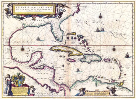
The Blaeu family of Amsterdam produced many of the most beautiful and celebrated cartographic works to come out of the Age of Discovery. Willem Blaeu, who studied under Tycho Brahe, founded a publishing house and mapmaking firm in 1596. After Willem's death, the business passed to his sons and continued to operate until a fire destroyed their workshop in 1672 (Tooley, 1999). This map draws from an earlier, extremely rare chart by Hessel Gerritsz (Burden, 1996). It shows the southern portion of North America, Mexico's Yucatan Peninsula, the West Indies, and Central America. Virginia is clearly marked and the entire southern portion of North America is called Florida, as was typical for maps of this period. The diagonal lines emanating from the compass roses are called rhumb lines and were used for navigation. The Blaeus lushly decorated their maps and this one is no exception. The cartouche at the top left corner has several frightening looking lizards, a bat, snakes, and a large turtle.
Click here to view a full size image
 Novissima et accuratissima totius Americae descriptio, c. 1673. Gift of Joseph H. Woodward, II.
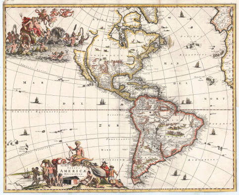
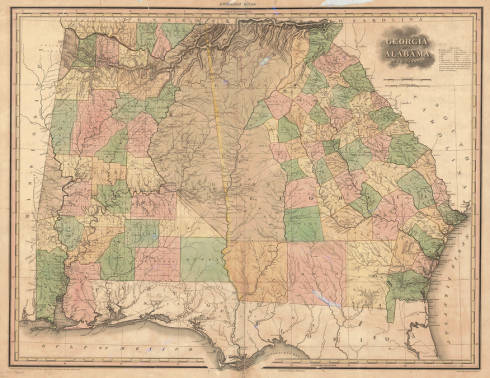
This map is one of the many revisions of an earlier version by Visscher (Tooley, Mapping of America, p. 119, p. 121), with one of its most striking features being the depiction of California as an island. The stunning cartouche in the upper left featuring Neptune's court is a new feature of this revision by Meurs (Tooley, p. 121). The North American continent is decorated with various forms of wildlife, including what is clearly a wild pig in the Western area. In the Southeastern section, Virginia is visible though the Southern regions are labeled La Florida, and the Florida peninsula appears somewhat truncated in comparison with modern renderings.
Click here to view a full size image
 La Floride: Suivant les Nouvelles Observations de Messrs. de l'Academie des Sciences, etc.: Augmentées de Nouveau., c. 1713
Pieter van der Aa was a publisher, editor, and bookseller in the Dutch city of Leiden. This map appeared in his Le Nouveau Théâtre du Monde ou la Géographie Royale which was published in 1713. It appears to be heavily derived from an earlier map by the foremost French cartographer, Guillaume Delisle (Tooley, 1999). Many Native American villages and tribes are marked, including the Alihamous tribe in the area of present day Alabama. This is one of the many variations we see on the name of the tribe from which Alabama took its name. This map has a large decorative cartouche at the bottom center which shows Native Americans in friendly conversation on one side and a smiling lion on the other. A palm tree and deer are in the background (Cumming, 1998, p. 204).
Click here to view a full size image
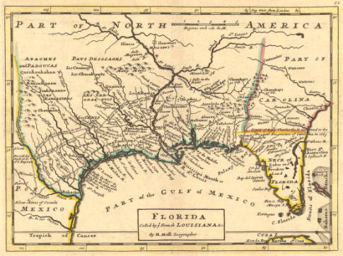 Florida, called by ye French Louisiana &c, 1736. Gift of Rucker Agee.
This early map of the southern colonies by Herman Moll offers fascinating details and historical insights. The Mobile River is clearly indicated as is the area inhabited by the Halbamas (or Alibamu) people. Pensacola is described as a fort built by the Spanish and as the best harbor of Florida. The routes of several explorers are marked, including the route of St. Denis's 1713 expedition through present-day Texas and La Salle's final expedition in 1687 (Cumming, 1998, p. 225).
Click here to view a full size image
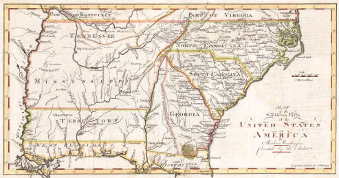
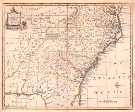 A new & accurate map of the provinces of North & South Carolina, Georgia & c, 1747
This detailed map shows the Carolinas, Georgia, Florida, and parts of Louisiana. It does not include all of present-day Alabama, but does include the eastern section and indicates the location of the Alabamous people and the river of the same name. An interesting description of the Cherokee people has been inserted in the center portion of the map and a lovely, decorative cartouche is located in the top, left corner. Emanuel Bowen was one of the leading mapmakers of the 18th century. Based in London, he served as mentor to other well-known cartographers such as Thomas Kitchen and Thomas Jefferys (Tooley, 1999).
Click here to view a full size image
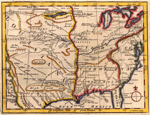 Map of Louisiana, Virginia, Carolina, Georgia, and Florida, 1763
This 1763 map of the American Southeast from the Gentleman's Magazineof London, England would have been useful to travelers. It indicates Native American lands and European holdings. Labels such as "Country of the Sioux"(top center) and "The Nation of Otters"(top left) are included along with markers for settlements, forts, garrisons, and mines. In the region that will become Alabama, the familiar tribal names of the state appear: Creeks, Chactaws, Chicasaws, and Cherokees. Along the mountain range at the far right is a note that "Formerly the French claim'd all ye Country Westward of this Line," a reminder of the changes in the world picture occurring in the eighteenth century.
Click here to view a full size image
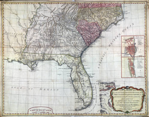
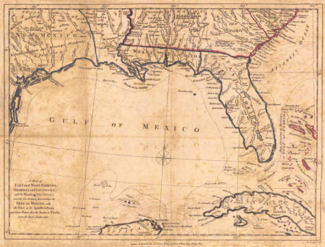 A map of East and West Florida, Georgia, and Louisiana, 1781. Gift of Joseph H. Woodward, II.
Having been captured by the Spanish during the American Revolution, the city of Mobile was under Spanish rule from 1780-1813. This map, published in London in 1781, already shows Mobile as part of the colony known as West Florida.
Click here to view a full size image
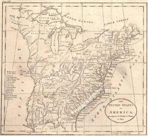 The United States of America, according to the Treaty of Peace of 1784, c. 1784. Gift of Rucker Agee.
This is an early map of the United States following the American Revolution which was formally ended with the signing of the Treaty of Paris. The treaty was signed on September 3, 1783, and ratified by the United States on Janaury 14, 1784. Lands set aside for military veterans are indicated as are the locations of various tribes of Native Americans. The area that would become Alabama is, at this point, part of Georgia. Shown on this map is the "Tennessee Government" which refers to the State of Franklin, an area in present-day eastern Tennessee which was established in 1784.
Click here to view a full size image
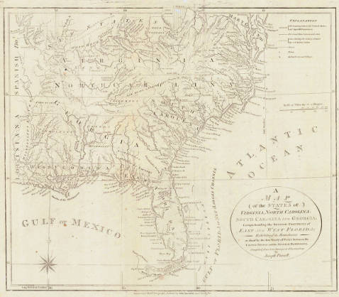 Map of the states of Virginia, North Carolina, South Carolina and Georgia: comprehending the Spanish provinces of east and west Florida: exhibiting the boundaries as fixed by the late treaty of peace between the United States and the Spanish dominions, 1792. Gift of Rucker Agee.
This map first appeared in the 1789 edition of American Geography by Jedidiah Morse. It provides a very detailed look at the southeastern states and territories of the United States. Native American tribes are indicated as are many rivers and tributaries. Also included is the New State of Franklin located in eastern Tennessee. Originally carved out of North Carolina in 1784, the area ceased to exist in 1788 but continued to appear on maps. Jedidiah Morse was a minister who also gained great recognition as a geographer. He was the father of Samuel F.B. Morse, inventor of the telegraph and Morse code, and of Sidney Edwards Morse who went on to become a map maker and inventor in his own right (Woodward, 1977).
Click here to view a full size image
 A new and general map of the Southern dominions belonging to the United States of America: viz North Carolina, South Carolina, and Georgia with the bordering Indian countries, and the Spanish possessions of Louisiana and Florida, 1794. Gift of Rucker Agee.
This is a reissue of a map originally printed in London in 1776 (hence the Atlantic Ocean is also called the Western Ocean). The title of the map has been updated to reflect the status of the United States as an independent country. Included are many rivers, trails, villages, locations of Native Americans, and some interesting notes about them. Note that Mobile is still part of West Florida and will not become part of the United States until 1813.
Click here to view a full size image
 Map of the southern parts of the United States of America, c. 1804. Gift of Joseph H. Woodward, II.
This map, issued in 1804, reflects the fact that Georgia has ceded its claims to land north of the 33rd parallel allowing it to be incorporated into the Mississippi Territory. The lines running east to west between the 32nd and 33rd parallels and at the 31st parallel represent the original northern and southern boundaries of the Mississippi Territory which was established on April 7, 1798, and includes present-day Alabama.
Click here to view a full size image
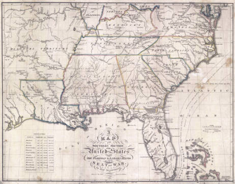 A map of the southern section of the United States: including the Floridas & Bahama islands shewing the seat of war in that department, 1813. Gift of Rucker Agee.
Contained in John Melish's Military and Topographical History of the United States, this map shows the southeastern United States including the Mississippi Territory. The map reflects the fact that the City of Mobile is firmly located within the United States at this point. Several interesting facts are included on this map. For instance, within the Missouri Territory there is a point from which "the alligators go no further north." Also shown on this map is a spot where Pike's expedition, led by Zebulon Pike, stopped briefly.
Click here to view a full size image
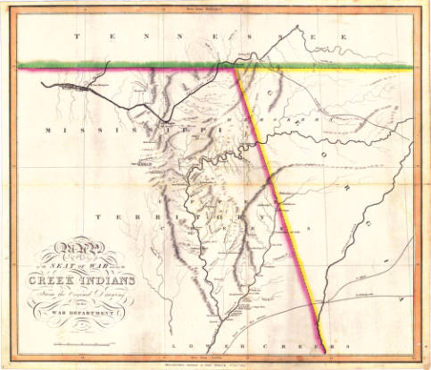 Map of the seat of war among the Creek Indians: From the original drawing in the War Department, 1814. Gift of Rucker Agee.
This is another map from Melish's Military and Topographical History of the United States. It indicates the areas in Alabama (as part of the Mississippi Territory) and Georgia where the Creeks were settled, naming many of their villages. General Andrew Jackson's route through the Creek lands from Huntsville to Tuskegee is marked.
Click here to view a full size image
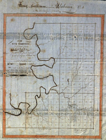 Map of four townships in Marengo County, Alabama: Granted to the French immigrants by act of Congress 3rd March 1817, c. 1817. Gift of Rucker Agee.
Fearing retaliation by the newly reinstated French monarch, a group of French citizens loyal to Napoleon Bonaparte sought refuge in the United States in 1817. This map shows the townships in Marengo County that were set aside for their use and settlement. The primary objective of the colony was the farming of grapes and olives. Hence, the settlement came to be known as the Vine and Olive Colony. Unfortunately, the soil of Marengo County was not conducive to the cultivation of grapes or olives. After news of Napoleon's death in 1821 reached the colony, most of the original settlers either retuned to France or moved to cities such as New Orleans and Mobile which had large, well established French communities (Smith, 1967).
Click here to view a full size image
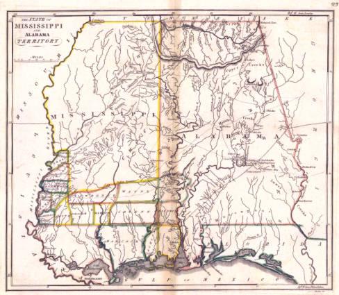 The state of Mississippi and Alabama territory, 1818. Gift of Rucker Agee.
This map from 1818 shows Mississippi as a state and Alabama as a territory. In only one year, Alabama would also join the United States as the 22nd state. Counties are beginning to emerge with Washington and Baldwin being among the first.
Click here to view a full size image
 Map of Alabama constructed from the surveys in the General Land Office and other documents, 1818, 2001 reprint
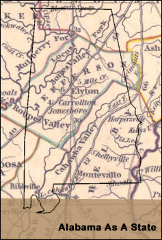
Using his trademark attention to detail, John Melish created this, the first map to show Alabama (either as a state or territory) by itself. At first glance this map may appear sparse, yet once closely examined it provides many interesting details about the history of Alabama up to this point. While there is no Jefferson County yet, there is an area marked with the notation, "Jones Valley containing 4000 inhabitants." Several other interesting notes and labels appear. There is a reference in Marengo County to the land granted to French immigrants. Several references appear to General Andrew Jackson's campaigns in the Creek War of 1813-1814. Lands occupied by the Creek, Cherokee, Choctaw, and Chickasaw are clearly labeled as are many villages within the Creek territory. On the right is information about the area's geology, soil quality, and mineral deposits.
Click here to view a full size image
|
The maps in this gallery show some of the earliest depictions of North America and chart the development of the United States and its growing territory. Extraordinarily beautiful maps by notable cartographers such as Sebastian Munster, Abraham Ortelius, Jocodus Hondius, and Willem Blaeu are shown here.
The area that would become Alabama is identified in very early maps as Florida or La Floride. As nations and states begin to emerge, Alabama is, initially, part of Georgia and later Mississippi before finally gaining status as a territory of the United States in 1817. Interestingly, the area around Mobile was captured by the Spanish during the American Revolution and remained part of Spanish West Florida until 1813.
While these maps depict an area that is undergoing continual change, the presence of Native Americans remains constant. Maps from the 1730's include the Cherokee, Creek, Choctaw, and Chickasaw; names familiar to all Alabamians. A century before Alabama's statehood, their societies were thriving throughout the Southeast.
|
|
| |
|
|
 Geographical, statistical, and historical map of Alabama, c.1822. Gift of Rucker Agee.
This early map of Alabama shows the development of many of the state's counties and provides population statistics (taken from the 1820 census). Also included is information about the various river systems, climate, soil, etc. Lastly, it provides a detailed history of the state from the time of de Soto's expedition to the present.
Click here to view a full size image
 Mississippi and Alabama, c. 1822. Gift of Rucker Agee.
This small map appeared in a book for students titled A Geography for Schools by Luke Drury. It clearly depicts the states of Alabama and Mississippi, along with West Florida. Only a few Alabama towns are indicated on this map including Huntsville, Mobile, and Blakely. Once a port city to rival Mobile, the town of Blakely in Baldwin County was established in 1813 but was abandoned over time due to numerous epidemics of yellow fever (Harris, 1982). Now a ghost town, Blakely is part of the Historic Blakely State Park.
Click here to view a full size image
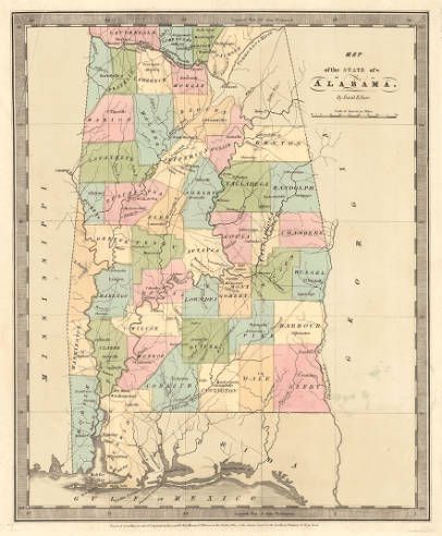
 Georgia and Alabama, 1823. Gift of Rucker Agee.
The familiar outlines of many Alabama counties are clearly visible in this dual map of Alabama and Georgia by Henry S. Tanner, one of the most prominent mapmakers in the United States during the early 19th century. Several counties such as Tuscaloosa and Pickens are quite large and will gradually be carved up to create additional counties. Decatur County in north Alabama was deemed too small to be a county and those lands were later split between Madison and Jackson Counties. Also indicated are lands occupied by the Creek, Cherokee, Chickasaw, and Chocktaw. Alabama's state capital at this time was located in the town of Cahaba in Dallas County.
Click here to view a full size image
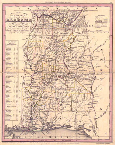 A new map of Alabama with its roads & distances from place to place, along the stage & steam boat routes, 1833. Gift of Rucker Agee.
Tanner's 1833 map of Alabama shows the state's existing counties and towns. As well as the current and proposed railroads and canals. Tuscaloosa was the state capital at the time, but many other familiar cities are also indicated as are the lands occupied by the Cherokee, Creek, Chickasaw, and Choctaw. On the left is a chart detailing the steamboat routes used for travel from Mobile to Montgomery, Tuscaloosa, and Pensacola. Henry S. Tanner had a long and prolific career in publishing and mapmaking. He is "thought to be the first native-born American to devote his career to publishing" (Tooley, 2004, p. 246). During the course of his work, he collaborated with other prominent mapmakers such as John Melish and Lucas Fielding (Tooley, 2004).
Click here to view a full size image
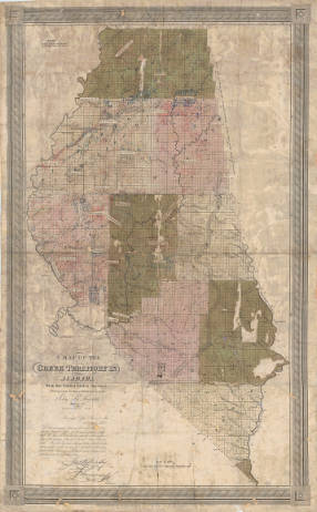 A map of the Creek territory in Alabama from the United States surveys: shewing each section & fractional section, 1833. Gift of Rucker Agee.
This is an excellent example of a map that includes a user's annotations or modifications, also known as an inscribed map. In this map, labels indicating Creek tribes or their territories have been carefully typed, cut out, and pasted onto the map. The labels are a wonderful reminder of the practical purposes these maps served. Removal of the Creeks was in progress at the time of this map's publication and their lands were open for settlement. Note that section number 16 (one square mile) within each township has been clearly labeled. The Land Ordinance of May 20, 1785, mandated that section 16 be set aside for public education.
Click here to view a full size image
 Map of the state of Alabama, 1834. Gift of Rucker Agee.
Produced in 1834, four years after President Andrew Jackson signed the Indian Removal Act, this map stands in contrast to all of the earlier maps in the exhibit in that it shows no Native American lands or villages within the State of Alabama. The removal of the Five Civilized Tribes from their lands east of the Mississippi River had begun in the 1820's and would continue until 1838.
Click here to view a full size image
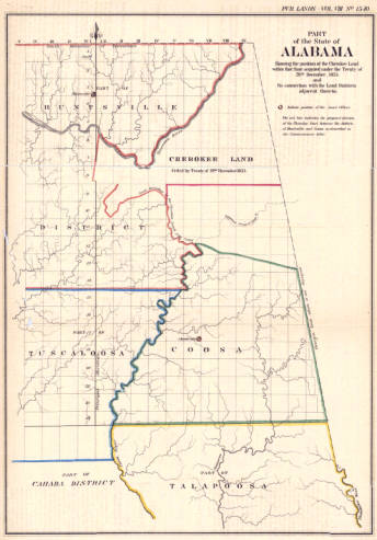 Part of the State of Alabama : showing the position of the Cherokee Land within that state acquired under the Treaty of 29th December, 1835, and its connection with the land districts adjacent thereto, c. 1861. Gift of Rucker Agee.
The Cherokee ceded their land in northeastern Alabama as a result of the Treaty of New Echota which was signed on December 29, 1835. Although challenged in court, the treaty was eventually upheld and the Cherokee were removed from Alabama, Georgia, Tennessee, and South Carolina to Indian Territory in 1838. Known as the Trail of Tears, a large percentage of the 15,000 Cherokee died as a result of the harsh conditions they endured on the forced march to present day Oklahoma (Hill, 2013).
Click here to view a full size image
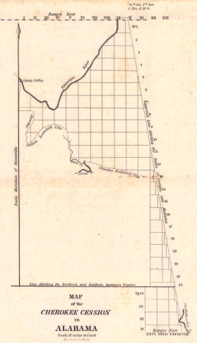 Map of the Cherokee Cession in Alabama, 1838. Gift of Rucker Agee.
This sketch showing Cherokee lands in eastern Alabama, was included in the Annual Report of the Commissioner of the General Land Office as submitted to Congress on December 18, 1838. The Surveyor General of the Public Lands in Alabama, James H. Weakley, included it as part of his request for funds to survey the lands from which the Cherokee were being removed. Weakley estimates that it will cost $22,400 to survey the 5,600 miles of vacated land and states that, "the anticipated difficulties with that tribe have been adjusted, and settled satisfactorily to the Government and the Indians, and they are now in the progress of peaceable removal, and will all have left during the present autumn" (S. Doc. No. 17, 1838).
Click here to view a full size image
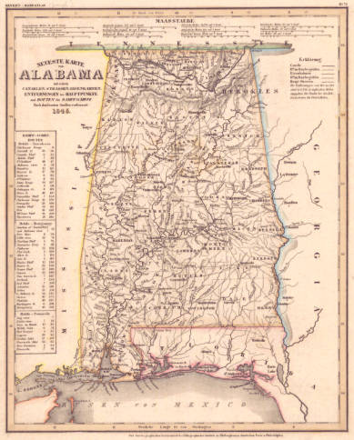 Neueste Karte von Alabama : mit seinen, Canaelen, Strassen, Eisenbahnen, Entfernungen der Hauptpunkte und Routen für Dampfschiffe nach den bessten Quellen verbessert, 1845. Gift of Rucker Agee.
This map appeared in Julius Meyers's Handaltas, a German language atlas of the Americas. Most of the plates were derived largely from maps created by Henry S. Tanner. Although dated 1845, this map is obviously based on an earlier version. Cherokee and Choctaw lands are still shown even though both groups ceded their land and were removed from Alabama in the 1830's.
Click here to view a full size image
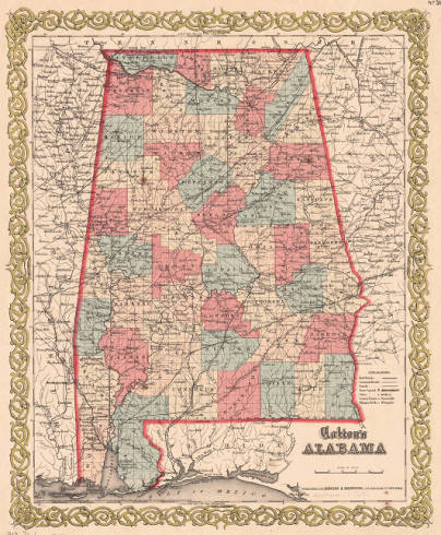
 Alabama, 1848. Gift of Rucker Agee.
Sidney Morse continued the tradition of geography and map making started by his father, Jedidiah Morse. Sidney Morse's contribution to the world of maps involved the creation of a new technique of wax engraving called cerography. This new process, "appeared on the scene in time to serve the needs of the rapidly growing mass market for popular maps in guidebooks, encyclopedias, school, and family atlases" (Woodward, 1977, pp. 23-24). Thanks to Morse's invention, maps began to regularly appear in textbooks and school geographies (Woodward, 1977). This map by Morse appears to have been part of his Cerographic Atlas of the United States.
Click here to view a full size image
 Alabama, 1859. Gift of Rucker Agee.
This map by Colton shows Alabama's counties and towns as well as its early railway system just prior to the Civil War. In the 1850's, railroads in Alabama were used primarily for the benefit of farmers rather than as a method of transportation. Farmers would use the railroads to transport "farm and plantation products to river landings, where the steamboats took over" (Cline, 1997, p. 41). Citizens were reluctant to financially support a new mode of transportation in which they had little confidence. As a result, when the Civil War broke out in 1861, "Alabama's infant rail system was ill equipped to handle the demands" (Cline, 1997, p. 50).
Click here to view a full size image
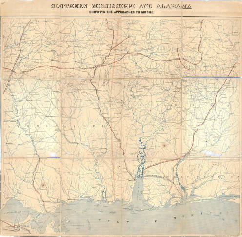 Southern Mississippi and Alabama showing the approaches to Mobile, 1863. Gift of Rucker Agee.
Established in 1807, the U.S. Coast Survey employed some of the nation's best scientists and engineers in order to create detailed topographic and coastal surveys. Under the guidance of their longtime director, Alexander Bache (great grandson of Benjamin Franklin), the Survey set the standard worldwide for using the latest scientific technologies, such as photography and the telegraph, in map making. When the Civil War broke out the U.S. Coast Survey was readily able to produce highly detailed maps of the Confederate States in order to aid the Union Army in the transportation of soldiers and their supplies (Cloud, 2011). This map shows the various ways of reaching the city of Mobile, either by rail, water, or road. It also includes the names of towns and even the location of a gold mine.
Click here to view a full size image
|
Alabama became the 22nd state of the United States on December 14, 1819. The state's early years were active ones. The maps shown here chart Alabama's growth and show the development of the state's cities and counties. Also shown is the abrupt removal of Native Americans. Using instruments such as the Indian Removal Act of 1830 and the Treaty of New Echota, the United States forcibly removed tens of thousands of people whose ancestors had lived in Alabama for hundreds of years. Many of them suffered and died as they marched across harsh terrain to Indian Territory in present day Oklahoma.
These maps demonstrate that Alabama, a primarily agricultural state, was slow to embrace the railroad and relied heavily on steamboats to transport farming equipment and produce over long distances. On the eve of the Civil War, Alabama was without an adequate rail system needed for the safe and efficient movement of troops and supplies.
|
|
| |
|
|
 Colton's Map of the State of Alabama, 1872. Gift of Rucker Agee.
Published in 1872, this map shows the familiar outline of Alabama and its counties. Making an early appearance is the City of Birmingham in Jefferson County. Having been incorporated on December 19, 1871, this may be one of the first state maps to show Birmingham. Look closely, however, and you will notice another Birmingham in Jackson County. Established on December 29, 1845, and renamed Princeton on April 1, 1849, it should have disappeared from maps by this point (Harris, 1982). This map is, therefore, quite unique in that it shows both of Alabama's Birminghams even though the two towns never actually co-existed.
Click here to view a full size image
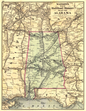 Watson's new railroad and distance map of Alabama, 1877. Gift of Rucker Agee.
This map, by Gaylord Watson, shows the railroad system that began to emerge in Alabama after the Civil War. As the mineral wealth of the area was being realized, so was the need for a railroad system to transport that wealth out of central Alabama. State Geologist Michael Toumey, "showed the world that Alabama possessed enormous mineral resources, but it was clear that these resources were worthless unless a viable transportation method could be put in place to haul them to market" (Cline, 1997, p. 44). Birmingham's growth could not happen without the railroads. After a complicated series of deals and maneuvers, the City of Birmingham was born at the crossing of the South and North Railroad (later L&N) and the Alabama and Chattanooga Railrod (Atkins, 1996).
Click here to view a full size image
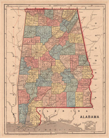
 Alabama, 1885. Gift of Rucker Agee.
Taken from engraver and publisher George F. Cram's Unrivaled Family Atlas of the World, this map shows Alabama with all its counties, towns, rivers, and railroads. George F. Cram started his publishing company in Chicago in 1869 and went on to publish maps and atlases well into the 20th century (Tooley, 1999). By 1885 almost all of Alabama's 67 counties were well established, with the exception of Houston County which was formed from parts of Dale, Geneva, and Henry counties in 1903. While small changes to the county boundaries would continue to occur through the 1980's, this map shows Alabama much as it is today (Long, 1993).
Click here to view a full size image
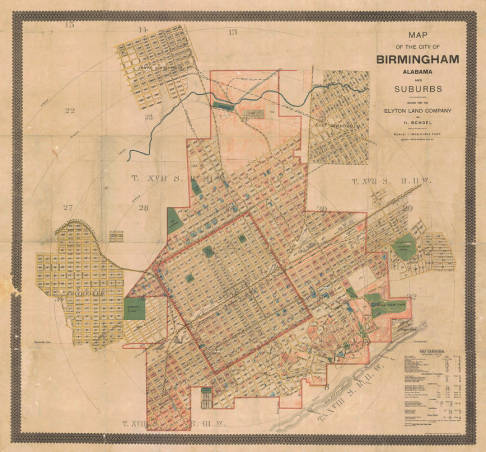 Map of the City of Birmingham Alabama and suburbs drawn for the Elyton Land Company, 1888. Gift of Rucker Agee.
This map shows the relatively new (incorporated in 1871) town of Birmingham and several of the surrounding suburbs. Many familiar streets and parks are clearly visible. The square outlined in red in the center of the map shows the boundaries of the city. Many of Birmingham's current neighborhoods such as Avondale, Smithfield, and North Birmingham were not part of Birmingham proper until the passage of the Greater Birmingham Act in 1910 which annexed the surrounding communities and towns. These annexations increased Birmingham's area from 3 to 48 square miles and more than doubled the population (Newbill, 1980). Segregation was in force at this time as indicated by the listing of schools and churches. Linn Park does not appear because at the time it was called Capitol Park. Originally called Central Park the name was changed in 1886. In 1918, it was renamed Woodrow Wilson Park and on October 4, 1988, the name was changed once again in honor of Charles Linn, Birmingham pioneer and businessman.
Click here to view a full size image
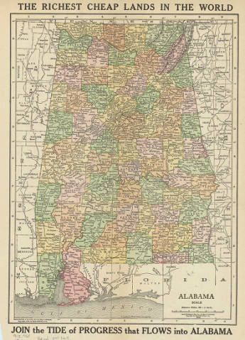 Alabama, 1912
This early 20th century map of Alabama shows the counties, cities, towns, and railroads. The map encourages people to settle in Alabama by advertising the state as having the "Richest Cheap Lands in the World" and by telling people to "JOIN the TIDE of PROGRESS that FLOWS into ALABAMA." A copy of this map appeared in the 1912 edition of Alabama's New Era, the official bulletin of the State Immigration Department, the purpose of which was to "let the outside world know something of the unparalleled opportunities to be had in Alabama" (Alabama State Department of Immigration, 1912, p. 3).
Click here to view a full size image
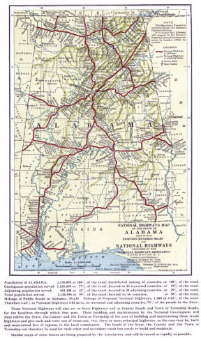 National highways map of the state of Alabama showing eighteen hundred miles of national highways proposed by the National Highways AssociationAlabama, 1913. Gift of Rucker Agee.
Charles H. Davis founded the National Highways Association (NHA) in 1911 to champion a 50,000-mile network of roadways built and managed directly by the federal government. This proposal sought to circumvent constitutional objections to federal roadway financing. It competed directly with the rising sentiment for federal appropriations to states to link highways across state lines, but also incorporated this federal aid schema into its "Four-Fold System" of federally-managed highways fed by state-federal highways that, in turn, were fed by state-county roads. County-financed market roads then served local farmers. With its slogan, "Good Roads Everywhere," the National Highways Association peaked in 1913 when it issued a system-wide map and forty-eight state maps showing proposed routes. Alabama Senator John Bankhead's 1916 Federal Aid Road Act overwhelmed the NHA's plan. Poor performance by state highway departments led to a revival of NHA ideas until the 1921 Federal Highway Act ensured the current federal-state partnership in highway building.
Click here to view a full size image
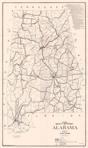 Alabama State Highway Department: system of state roads, 1927
Released in 1927, this map shows the system of state and federal roads in Alabama. The symbols on the legend indicate the surface of the road (paved, gravel, etc.) and there is even a symbol for projected roads. A detailed description of the federal roads in Alabama appears in the upper right corner. Alabama's Highway Department was hard at work maintaining and repairing the State's system of roads and undertaking the construction of new roads and bridges. Alabamians were eager to take advantage of the new roads as evidenced by the fact that 210,078 passenger vehicles were registered in Alabama in 1927 (Alabama State Highway Department, 1927).
Click here to view a full size image
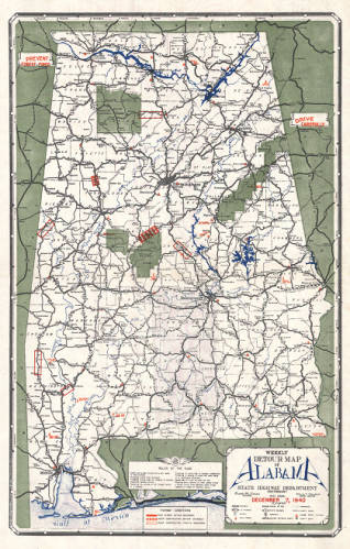 Weekly detour map of Alabama, December 7, 1940, 1940
Produced by the Alabama State Highway Department, the weekly detour map was designed to give motorists a way to plan their trips around construction and road closures. The legend indicates if a particular road is closed, if a detour is advisable due to ongoing construction, or if a road is still open despite being under construction. Also listed are the locations of highway patrol stations, airports, and state parks. Drivers could probably have obtained a weekly detour map from the highway patrol or the Highway Department.
Click here to view a full size image
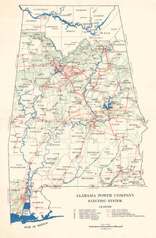 Alabama Power Company electric transmission & distribution system, 1954. Gift of Rucker Agee.
This map shows the distribution of electricity across the area of Alabama that was served by the Alabama Power Company. Founded in 1906, the Alabama Power Company provides electricity and hydroelectric power to almost all of the state. The northern portion of Alabama is served by the Tennessee Valley Authority (TVA). Built between 1912 and 1928, the four hydroelectric dams on the Coosa and Tallapoosa Rivers (Martin, Lay, Mitchell, and Jordan Dams) represented, "the largest, most complex, and most expensive construction projects in the history of the state" (Jackson, 1997, p. 1).
Click here to view a full size image
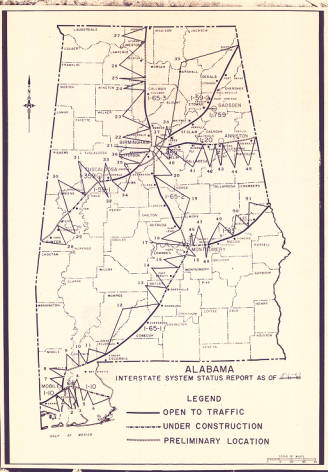 Alabama interstate system status report as of 5-1-67, 1967
Even though construction of America's Interstate Highway System had begun in the 1950s during the term of President Dwight D. Eisenhower, a look at this map will show that it was still far from complete in May of 1967. Broken lines indicate areas either selected for a future stretch of interstate or portions still under construction; at this time, a trip of any length generally meant several changes between the interstate system and older county highways.
Click here to view a full size image
 Employment in Alabama Counties, 1975. Gift of Rucker Agee.
This interesting map from 1975 shows employment by county in various non-agricultural areas. Located in each county is a color-coded box. Each tier within the box symbolizes a different sector of employment (transportation, mining, retail, government, etc.). According to the map, "the horizontal and vertical scale of the boxes is a function of the square root of the labor force and employment in March 1974." Put simply, the larger the box, the larger the work force.
Click here to view a full size image
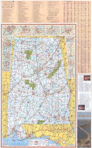 Official Alabama Highway Map, 1997. Gift of Rucker Agee.
Regularly published by the Alabama State Highway Department, this map from 1997 shows modern day Alabama with highways, interstates, state, and county roads marked. Highway maps were essential tools for travelers in the days before GPS systems and smart phones. Major attractions, state parks, museums, and even covered bridges are all labeled. Everything anyone needed to know about touring Alabama can be found here.
Click here to view a full size image
|
As shown on the maps in this gallery, Alabama wasted no time developing a network of railroads after the Civil War. Later on, we see the first state highways and eventually the beginnings of the interstate system.
Incorporated in 1871, Birmingham starts appearing on maps for the first time.
Thanks to the mineral deposits in the area Birmingham grew quickly, earning the nickname of "The Magic City." However, all of Alabama was ready and willing to embrace growth, industry, and new development.
|
|
| |
|
|
 Geological map of Alabama, 1849. Gift of Rucker Agee.
Born in Ireland, Michael Tuomey was the first State Geologist of Alabama. His appointment was approved on January 4, 1848, by Governor Reuben Chapman. Shortly after his appointment he produced an extensive report on the geology of Alabama. He also drew this, the first geological map of Alabama, in 1849. Thanks to Tuomey's work, "southern capitalists were induced for the first time to invest their funds in coal and iron companies. Tuomey's report set the Governor and the legislature to thinking that Alabama had possibly another industrial future besides growing cotton" (Armes, 1972, p. 103).
Click here to view a full size image
 State of Alabama, 1866. Gift of Rucker Agee.
In order to encourage railroad construction, the Federal Government made public lands available to railroad owners in the form of land grants with the hope that the companies would sell the land and use the profits to pay the costs of building the railroad. This 1866 map shows the routes of Alabama's land grant railroads. The land grants, "helped insure the survival of many Alabama railroads - not because the land was immediately sold to finance construction, but because of the credit the roads could obtain by using these assets as collateral" (Cline, 1997, p. 39). Another interesting feature of this map is the note at the bottom stating that, "The whole central region of this state is underlaid with iron ore in vast beds. There are also coal measures of great thickness and extent. Lead ore is also found."
Click here to view a full size image
 Geological map of Alabama, 1878. Gift of Rucker Agee.
Alabama native Eugene Allen Smith was appointed State Geologist in 1873 and resumed the geological surveys that had ceased with the death of Michael Toumey in 1857. This is, in all probability, the first geological map of Alabama to include Birmingham. It is color coded to distinguish the various geological areas. Note that the entire region of central Alabama is indicated as having "coal measures." The map also has symbols indicating the locations of iron furnaces, iron ore banks, coal and other mines, and lime kilns throughout the state.
Click here to view a full size image
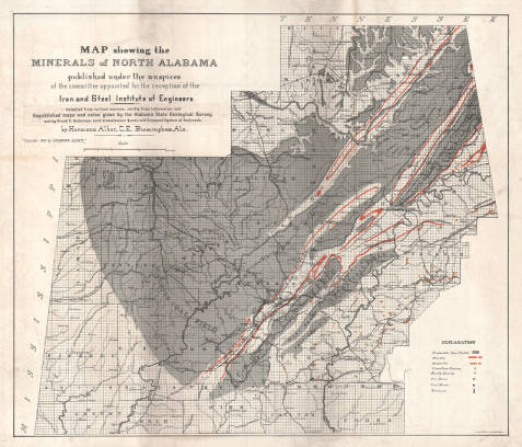 Map showing the minerals of North Alabama, 1890
Hermann Alber, a German born civil and mining engineer, drew this map showing the location and types of minerals in north Alabama. Its coverage extends to the area in and around Jefferson County. It strikingly illustrates the dominance of the Warrior Coal Field. State geologist, Michael Toumey identified 3 major coal fields in Alabama and named them the "Warrior, Cahaba, and Coosa fields for the rivers which drain them" (White, 1981, p. 33). The Warrior Coal Field was the largest by far and the most productive. In addition to coal, this map also shows the location of the marble quarries in and around Sylacauga in Talladega County. Alabama marble gained fame when sculptor Guiseppe Moretti (creator of Birmingham's Vulcan) began using it for his work in the early 1900's.
Click here to view a full size image
 General geologic map of Birmingham Valley, Alabama: showing distributions of formations and locations of mines and prospects, c. 1909. Gift of Rucker Agee.
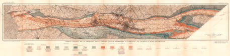
This map appeared in a bulletin published by the United States Geological Survey in 1909. At almost 200 pages, Iron Ores, Fuels, and Fluxes of the Birmingham District, Alabama is an incredibly detailed look at the geology, ores, and minerals located in and around Birmingham. This area came to be known as the Birmingham District. Geographically, the district "extends as a long narrow belt, about 75 miles long and 10 miles wide, trending northeast and southwest, from the vicinity of Springville and Village Springs at the northeast to a point about 8 miles below Vance at the southwest. Birmingham is near the middle of this area" (Burchard, 1909, p. 10). This map beautifully illustrates the unique geological properties of the Birmingham District which allowed it to flourish so quickly in the late 19th and early 20th centuries.
Click here to view a full size image
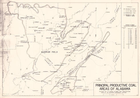 Principal productive coal areas of Alabama including key to Bureau of Mines coal investigations made at the southern experiment station, 1938
Created by the United States Bureau of Mines, this map shows the locations of central Alabama's coal mines. Many of the mines named on the map are familiar because they are also the names of company towns. Company towns were entire communities built for the employees of the mining company. They included housing, schools, libraries, churches, doctors, sports teams, and a company store. Some mining towns even had their own form of currency called scrip which could only be redeemed at the company store. Small and often isolated, company towns slowly began to disappear in the latter half of the 20th century due to the decline of mining (Day, 2015). However, many of these towns such as Docena, Wylam, and Edgwater are still recognized communities today.
Click here to view a full size image
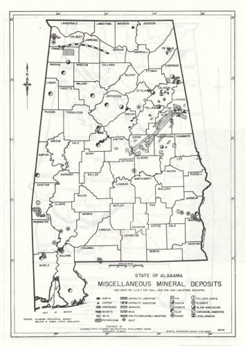 State of Alabama miscellaneous mineral deposits, 1960
Using simplistic illustrations, this map shows the locations of various mineral deposits throughout the state. Produced by the Alabama Geological Survey in 1960, we learn that several counties in eastern Alabama had gold deposits, that there were pockets of petroleum in southwestern Alabama, and that Fuller's earth, which is an absorbent substance used in cat litter, could be found in Barbour County.
Click here to view a full size image
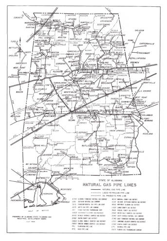 Natural gas pipe lines, state of Alabama, 1964
Natural gas and petroleum are the focus of this map. It shows the pipelines that carried gas and petroleum across the state as well as the names of the gas companies that owned them as of July 1964. Alabama's reserves of oil and natural gas have never received as much attention as its deposits of coal and iron ore. However, Alabama has a long history of oil and gas exploration and drilling, beginning in 1884 in Choctaw County. It took several years, but oil was eventually discovered in Alabama in 1887 near Decatur in Morgan County. Natural gas was discovered a few years later in Madison County in 1902 (Hughes, 1993).
Click here to view a full size image
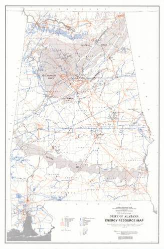 State of Alabama energy resource map, 1977
An immediately noticeable feature of this map is its emphasis on the vast deposits of coal across north and central Alabama in the areas designated as Plateau Field, Warrior Field, Cahaba Field, and Coosa Field, as well as the Lignite Belt further south. This 1977 depiction of Alabama’s energy resources, created more than a century after the founding of Birmingham, Alabama, is a striking reminder of the concentration of mineral wealth in that area.
Click here to view a full size image
|
No telling of Alabama's story would be complete without mentioning the importance of the state's natural resources. The great mineral wealth found in central Alabama allowed Birmingham to quickly become the state's largest city and an industrial powerhouse. As early as 1849, the importance and potential of the area's mineral deposits was being realized.
In addition to the coal and iron ore found in central Alabama, these maps depict resources such as Sylacauga marble, petroleum and natural gas, and even a few gold mines.
|
|
| |
|
|
The Birmingham Public Library would like to thank The Alabama Humanities Foundation, the state affiliate of the The National Endowment for the Humanities, Jay Lamar and the Alabama Bicentennial Commission, Dr. Melinda Kashuba and Dr. Martin Olliff for their input and guidance throughout the development of this exhibition, Jim Baggett of the Birmingham Public Library's Archives Department, Melinda Shelton of the Birmngham Public Library for her work on the web site and digital collections, and John DeMotte. We are especially grateful to Rucker Agee, John C. Henley III, Dr. Charles Ochs, and Joseph H. Woodward II for their generous gifts to the Birmingham Public Library.
Sweet Home: Alabama's History in Maps was curated by Mary Beth Newbill, Mary Anne Ellis, and Laura Gentry of the Birmingham Public Library's Southern History Department. The exhibition is available for travel. For more information or to purchase prints, call 205-226-3665 or email
askgenlocal@bham.lib.al.us.
|

 |